Sulphur Point / Fergusson Park / Whakapaewaka Bridge / Waikareao
Estuary Loop
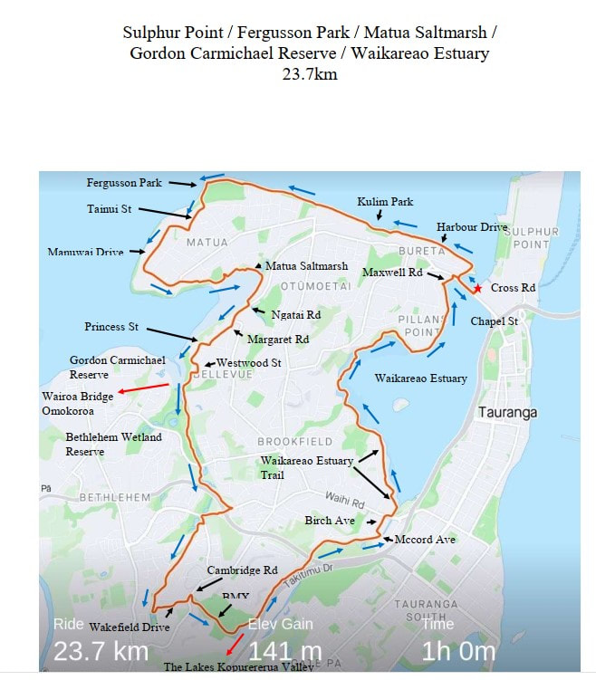
Approx: 23.7km
Time: 1 hr +
14.72 miles
About this ride: This is a mainly flat ride some quiet roads and off road paths
Area: Tauranga – Suburbs: Otumoetai, Matua, Bellevue, Bethlhem, Judea, Brookfield, Pillians
Point
Bike Type: A wider tyre is the sensible option as some of the route is unsealed
Park and start: Sulphur Point, Cross Rd by the boat ramp and Nautilus Restaurant and Bar.
The directions are from Cross Rd, where there is plenty of parking and toilets.
Directions:
Ride towards the Nautilus Restaurant taking the bridge over the water way. ( Between the boat
launching area and waterway ) From this vantage point you get a fabulous view down the
harbour to the Mount. Carefully under the rail bridge, turning right at the road bridge onto the
footpath, this is Chapel St, for 300m. Right onto Maxwell’s Road ( also on your left and
where you will come out of on your return ), for 240m, this flows left into Harbour drive for
appox 1.6km on the waterside shared path to Kulim park and on to Beach Rd to the end of
Fergusson Park for approx. 2.3km.
Exit Fergusson Park entry gates turning right into Tainui St, right into Matua Rd which flows
into Manuwai Drive to the end and left through Kings Ave Reserve which comes out onto
Kings Ave, directly right into Levers Rd, right into Sunny Bay Rd to the end where it meets
the Start of the Matua Saltmarsh path. ( steep concrete path down veering left, then onto
boardwalk ) Follow the paths veering right at intersecting pathways until you get to the wooden
arch ride through this, then veer right. At the end of the path under the railway and up onto
Ngatai Rd, turning right for 500m . Right into Margaret Rd for 250m, Right into Princess Rd
for 450m, Right into Westwood St for 120m turning right just past mail box 31., This side path
takes you out onto the wetlands. Sign posted Bethlehem. Turn left at the bottom of the path,
following the Bethlehem sign. Veering left following the Waihi Rd sign. This is Gordon
Carmichael Reserve and Tauranga Wetlands. Cross over Carmichael Rd continuing on the
wetland path, this comes out onto an access way with Kelvin Way on your left. Follow this
access way to the end and up a small footpath, Turn right onto the foot path with the traffic
coming towards you. Stay on the footpath with the traffic coming towards you, cross over the
road on your right and continue over the Motorway bridge through the roundabout ( this is
Beaumairs Blvd) and down the hill. Ride past the roundabout then cross the road and ride along
the footpath with traffic coming towards you which is Sterling Gate Drive. Take the path on
your right into Bethlehem Wetlands Reserve. Veer left after the double white railings. Riding
left when you reach the lake which takes you out onto Castlewold Drive, Ride left and then
immediately right into Wakefield Drive, up a steady hill to Cambridge Rd. turn left and then
immediately right into Cambridge Park and BMW track. ( BMX track access path on your
left ) Toilets on your right. Follow the Waihi Rd signs.
When you reach the river Option : turning right will take you up to the Lakes Kopurererua
Valley shared path. Or when you reach the river turn left still following the Waihi Rd signs
Follow the path to the end with the river on your right, Industrial area on your left until you come
to the steps ( and bike gutter ) which will take you up onto Mccord Ave, turn left here for 85m.
Right into Birch Ave for 220 turning right at the lights into Waihi Rd for 77m, then
immediately up onto the footpath on your left then left again before you reach the bridge. Do not
cross the bridge. You are now on the Waikareao Estuary track. , Follow the Estuary in a
clockwise direction ( keep veering right ) , over the boardwalks, riding through McCardles bush
and the Daisy Hardwick section. Turning right into Maxwell’s Rd at the end of the path for
180m, ( crossing at the pedestrian crossing on your left if the road is busy, this is Chapel St )
right into Chapel St
Refreshment Option: If you continue down Chapel St to the lights there is a shopping centre with
several eating options. The Raft has plenty of outside area for bikes.
Ride over the bridge for 300m turning immediately left onto the path you came in on. Arriving at
the Nautilus and Sulphur Point carpark.
Optional Extension refer to: Sulphur Point to the Marina and The Strand
Click here to download the detailed route description
Estuary Loop
Approx: 23.7km
Time: 1 hr +
14.72 miles
About this ride: This is a mainly flat ride some quiet roads and off road paths
Area: Tauranga – Suburbs: Otumoetai, Matua, Bellevue, Bethlhem, Judea, Brookfield, Pillians
Point
Bike Type: A wider tyre is the sensible option as some of the route is unsealed
Park and start: Sulphur Point, Cross Rd by the boat ramp and Nautilus Restaurant and Bar.
The directions are from Cross Rd, where there is plenty of parking and toilets.
Directions:
Ride towards the Nautilus Restaurant taking the bridge over the water way. ( Between the boat
launching area and waterway ) From this vantage point you get a fabulous view down the
harbour to the Mount. Carefully under the rail bridge, turning right at the road bridge onto the
footpath, this is Chapel St, for 300m. Right onto Maxwell’s Road ( also on your left and
where you will come out of on your return ), for 240m, this flows left into Harbour drive for
appox 1.6km on the waterside shared path to Kulim park and on to Beach Rd to the end of
Fergusson Park for approx. 2.3km.
Exit Fergusson Park entry gates turning right into Tainui St, right into Matua Rd which flows
into Manuwai Drive to the end and left through Kings Ave Reserve which comes out onto
Kings Ave, directly right into Levers Rd, right into Sunny Bay Rd to the end where it meets
the Start of the Matua Saltmarsh path. ( steep concrete path down veering left, then onto
boardwalk ) Follow the paths veering right at intersecting pathways until you get to the wooden
arch ride through this, then veer right. At the end of the path under the railway and up onto
Ngatai Rd, turning right for 500m . Right into Margaret Rd for 250m, Right into Princess Rd
for 450m, Right into Westwood St for 120m turning right just past mail box 31., This side path
takes you out onto the wetlands. Sign posted Bethlehem. Turn left at the bottom of the path,
following the Bethlehem sign. Veering left following the Waihi Rd sign. This is Gordon
Carmichael Reserve and Tauranga Wetlands. Cross over Carmichael Rd continuing on the
wetland path, this comes out onto an access way with Kelvin Way on your left. Follow this
access way to the end and up a small footpath, Turn right onto the foot path with the traffic
coming towards you. Stay on the footpath with the traffic coming towards you, cross over the
road on your right and continue over the Motorway bridge through the roundabout ( this is
Beaumairs Blvd) and down the hill. Ride past the roundabout then cross the road and ride along
the footpath with traffic coming towards you which is Sterling Gate Drive. Take the path on
your right into Bethlehem Wetlands Reserve. Veer left after the double white railings. Riding
left when you reach the lake which takes you out onto Castlewold Drive, Ride left and then
immediately right into Wakefield Drive, up a steady hill to Cambridge Rd. turn left and then
immediately right into Cambridge Park and BMW track. ( BMX track access path on your
left ) Toilets on your right. Follow the Waihi Rd signs.
When you reach the river Option : turning right will take you up to the Lakes Kopurererua
Valley shared path. Or when you reach the river turn left still following the Waihi Rd signs
Follow the path to the end with the river on your right, Industrial area on your left until you come
to the steps ( and bike gutter ) which will take you up onto Mccord Ave, turn left here for 85m.
Right into Birch Ave for 220 turning right at the lights into Waihi Rd for 77m, then
immediately up onto the footpath on your left then left again before you reach the bridge. Do not
cross the bridge. You are now on the Waikareao Estuary track. , Follow the Estuary in a
clockwise direction ( keep veering right ) , over the boardwalks, riding through McCardles bush
and the Daisy Hardwick section. Turning right into Maxwell’s Rd at the end of the path for
180m, ( crossing at the pedestrian crossing on your left if the road is busy, this is Chapel St )
right into Chapel St
Refreshment Option: If you continue down Chapel St to the lights there is a shopping centre with
several eating options. The Raft has plenty of outside area for bikes.
Ride over the bridge for 300m turning immediately left onto the path you came in on. Arriving at
the Nautilus and Sulphur Point carpark.
Optional Extension refer to: Sulphur Point to the Marina and The Strand
Click here to download the detailed route description